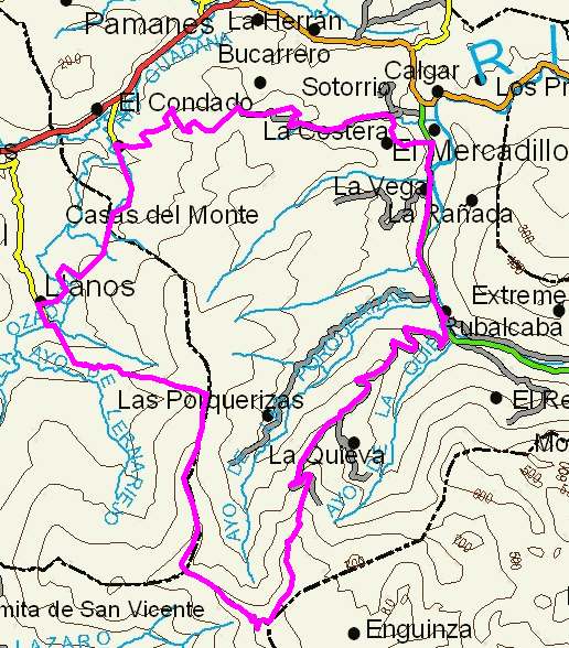
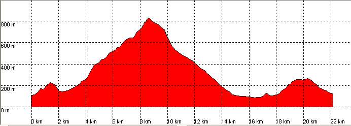
Casas de Monte, Pozos de Noja

Route 28

By: Javier Tovar, Pedro Ceballos, and Michael González Harbour


Basic Data

Click here to open the route in a Google Maps window. You will see it drawn on a satellite picture or a map. Use the controls in the upper part of the window to zoom into the map, reposition it, or to change the satellite.


Kilometers/Miles
22 / 14
Cummulative ascent: meters/feet
1030 / 3378
Maximum height
824 / 2703
Duration
4 and a half hours
Beginning and end location
Casas de Monte
Difficulty
High
Month
February
Recommended period
Summer-Autum, in a dry period

mapa route 28

Profile


Perfil route 28

Pictures


foto1
foto2
foto 3
foto 4
foto5
foto 6

Downloads

To open the route in Google Earth click on the 'KMZ' link and select 'Open with Goole Earth' (requires prior installation of Google Earth). To download a route, right-click on the link and select 'save link as' or a similar option.

Instructions

See the instructions and disclaimer, as well as other routes, in the main page.