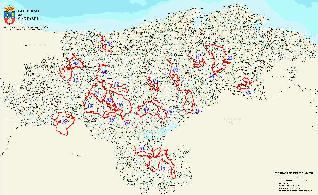
This page has been moved to http://cantabriaenbici.es
You will be redirected there.

Mountain Bike Routes in Cantabria, Spain

GPS Tracks

By: Javier Tovar, Pedro Ceballos, and Michael González Harbour


Contents


Visit Counter

cifra 1cifra 2cifra 3cifra 4cifra 5cifra 6
Foto
Ver esta página en español

UK flag

Introduction

In this page you can find mountain bike routes that we have enjoyed cycled in the beautiful mountains of Cantabria, in Spain. They are routes of mid difficulty that allow us to watch spectacular views of the landscapes that make us fall in love with this region. The routes are almost completely cyclable. Most of them go through mountain dirt roads, and some are on trails or even have some short cross country segments. Many also have an initial and final part on secondary roads.

All routes begin and end in the same place, so that we can get there by car, carying our bikes.

The routes can be viewed in 3D projected on satellite pictures thanks to the free Google Earth program. In addition to the tracks in Google Earth format, we also provide the GPS track files that you can download on your GPS receiver, maps of the routes, the altitude profiles, and pictures of the area. We have recently added a page where you can view the track on satellite pictures or maps, using the services of Google Maps.

We hope you enjoy them as much as we do!

Routes in Spring and Summer 2006


Number
Route
Kilometers
Cummulative ascent (m)
01
Ruente, Monte AA, Collada de Carmona, and ascent to Zarceillo
35
838
02
Fresneda, Los Tojos, Colsa, Balcón de La Cardosa
46
1.196
03
Corrobárceno, San Martín de Toranzo, Collado Gandarillas
44
831
04
Oyambre, Monte Corona, Cabezón de la Sal
31
491
05
Arenas de Iguña, Cueto Helguera, Anievas, Bostronizo, and church of San Román de Moroso
38
1.073
06
Bárcena de Pie de Concha, Mediajo Frío, Lanchares, Alsa
42
1.280
07
Correpoco, Bárcena Mayor and ascent to Ropero peek
56
1.116
08
Puente El Arrudo, Cires,  Venta de los Lobos, Collado de Hoz
39
1.056
09
Bárcena de Pie de Concha, Collado de Pagüenzo, Alsa
38
1.162
10
Celada-Marlantes, Somaloma, Aldea de Ebro, Cabaña de Higedo
52
1.338
11
Santa María de Cayón, Esles, Pozos de Noja
36
1.082
12
Selores, Correpoco, Ermita del Moral, Viaña
38
946
13
Valdeprado del Río (Km 5 of road S-614), Aldea de Ebro, Monte Higedo, Ruerrero, La Serna
76
1.288
14
Piedras Luengas, Caloca, Altos de Pineda, Lores
56
1.511
15
Renedo de Cabuérniga, Prado Concejo de Tudanca, Zarceillo
44
1486
16
Fresneda, Bárcena Mayor, Cruz de Fuentes, Ozcaba
58
1404

Routes in Autum and Winter 2006-2007

This section is in preparation. We will add more routes as we cycle them.

Number
Route
Kilometers
Cummulative ascent (m)
17
Puente El Arrudo, Quintanilla, Río Tanea, Puentenansa
46
1253
18
Saja, Ozcaba, Llano Castrillo, Rumaceo, Puerto de Palombera
50
1443
19
Saja, Tudanca, Embalse de la Cohilla, Sejos
67
2191
20
Rubalcaba, Valdició, Calseca, Alto de Somo
48
1316
21
Entrambasmestas, Coto Alisas, la Matanela, San Pedro del Romeral
41
964
22
Rubalcaba, Alto de Somo, Bustablado, Puerto de Alisas
57
1520
23
La Revilla, Bustancillés, La Gándara, Aja, San Pedro
42
968
24
Puente el Arrudo, Río Tanea, Collado de la Carrizosa, San Sebastián de Garabandal
45
992
25
Ruente, Ermita del Moral, Obios
52
1490
26
La Cavada, Rucandio, Tetas de Liérganes
31
643
27
Ruente, Collado de Monte Aa, San Sebastián de Garabandal
50
1136
28
Casas de Monte, Pozos de Noja
22
1030
29
Puente Nansa, San Sebastián de Garabandal, Collado de Abellán
39
949
30
Cabezón de la Sal, Monte Corona, Oyambre, San Vicente de la Barquera
48
907

Map of the routes

todas rutas

Instructions

Google Earth can be downloaded for free from http://earth.google.com/, and requires high-speed Internet connection (DSL o similar). After installing, you can open the "KMZ" files that you will find for each route. The program has controls to tilt the point of view and get a 3D display of the track.

The GPS tracks are offered in the popular formats PLT, of OziExplorer, and GRM, which is a Garmin PCX5 format.With them it is possible to open the route in a GPS route management application. Most GPS receivers have their own management program, and there are free applications to convert among the different file formats (for instance, POIConverter). Two popular GPS programs are:
The Datum used in the GPS tracks is WGS84. Remember that there may be significant differences, up to 300 meters, if you use an incorrect datum. Spanish cartography usually come with the European Datum.

For the maps shown in each route we have used maps of Cantabria of scale 1:100.000 from the Government of Cantabria, and the official road map of Cantabria, which are accessible for free in: http://www.gobcantabria.es/portal/page?_pageid=33,1409351&_dad=interportal&_schema=INTERPORTAL and in http://www.carreterasdecantabria.es/Mapas_Web/Elmapa.aspx, respectively. However, to plan the routes it is advisable to use maps of scale 1:50.000 or 1:25.000, wich are available in libraries. The 1:50.000 maps are less up to date, but can be found in the Instituto Geográfico Nacional.

To generate the Google Maps files we have used the converter available in GPS Visualizer.

Disclaimer

We have tried to ensure that the information in this page is correct, and we publish it with the intention that it is useful. However, it has to be used under your own responsability. We cannot be responsible of the consecuences of using this information, or of any errors that it may contain.

The information in this page can be copied and distributed only for non-profit purposes, and citing the source.

Contact Information

For any question or comment on this page you can send an e-mail to Michael González Harbour: contacto@cantabriaenbici.es