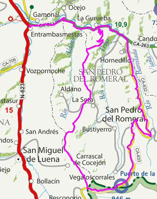
Entrambasmestas, Coto Alisas, la Matanela, San Pedro del Romeral

Route 21

By: Javier Tovar, Pedro Ceballos, and Michael González Harbour

Click here to open the route in a Google Maps window. You will see it drawn on a satellite picture or a map. Use the controls in the upper part of the window to zoom into the map, reposition it, or to change the satellite.
 

Basic Data

Kilometers/Miles
41 / 25
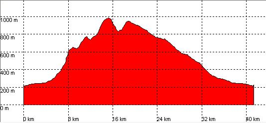
Cummulative ascent: meters/feet
964 / 3161
Maximum height
982 / 3221
Duration
3 hours
Beginning and end location
Entrambasmestas
Difficulty
Low
Month
November
Recommended period
All year round

route-21 mapa

Profile

route 21 perfil


Pictures


foto1
foto2
foto 3
foto 4

Downloads

To open the route in Google Earth click on the 'KMZ' link and select 'Open with Goole Earth' (requires prior installation of Google Earth). To download a route, right-click on the link and select 'save link as' or a similar option.

Instructions

See the instructions and disclaimer, as well as other routes, in the main page.